
Spatial Clarity for Complex Projects.
Digital Twins for architecture, infrastructure and large asset projects - from design to operations.
Tomorrowspace Spatial Digital Twins help project teams and asset owners coordinate design, communicate intent and keep data connected.
From concept design - through to delivery and operation.
Platform
Digital twins that evolve with your project.
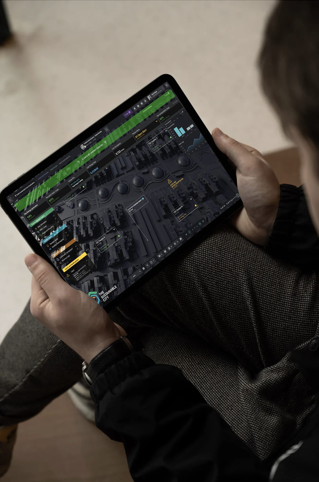
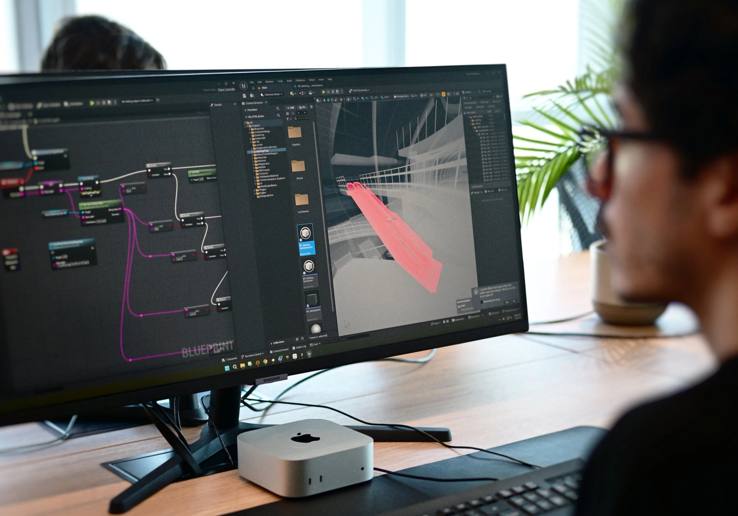
Tomorrowspace creates persistent spatial environments that connect models, project information and data within a shared spatial reference.
Every Spatial Twin combines Tomorrowspace’s growing suite of applications, enabling design review, analysis, stakeholder engagement and operational workflows from a single environment. As requirements evolve, new capabilities can be added without changing the underlying foundation.
For operational deployment, Tomorrowspace sits above existing systems rather than replacing them — providing the trusted lens and spatial context for decision-making while preserving existing technology investments.

Every twin starts with a clear use case.
Applications
Each Tomorrowspace Spatial Twin combines a growing suite of applications and interactive tools that can be added to support every stage of the project lifecycle.

-
Route Planning
Journey Time Analysis
Visibility Analysis
Section & Cutaway Tools
Phasing & Timeline Controls
Metrics & Measurement
-
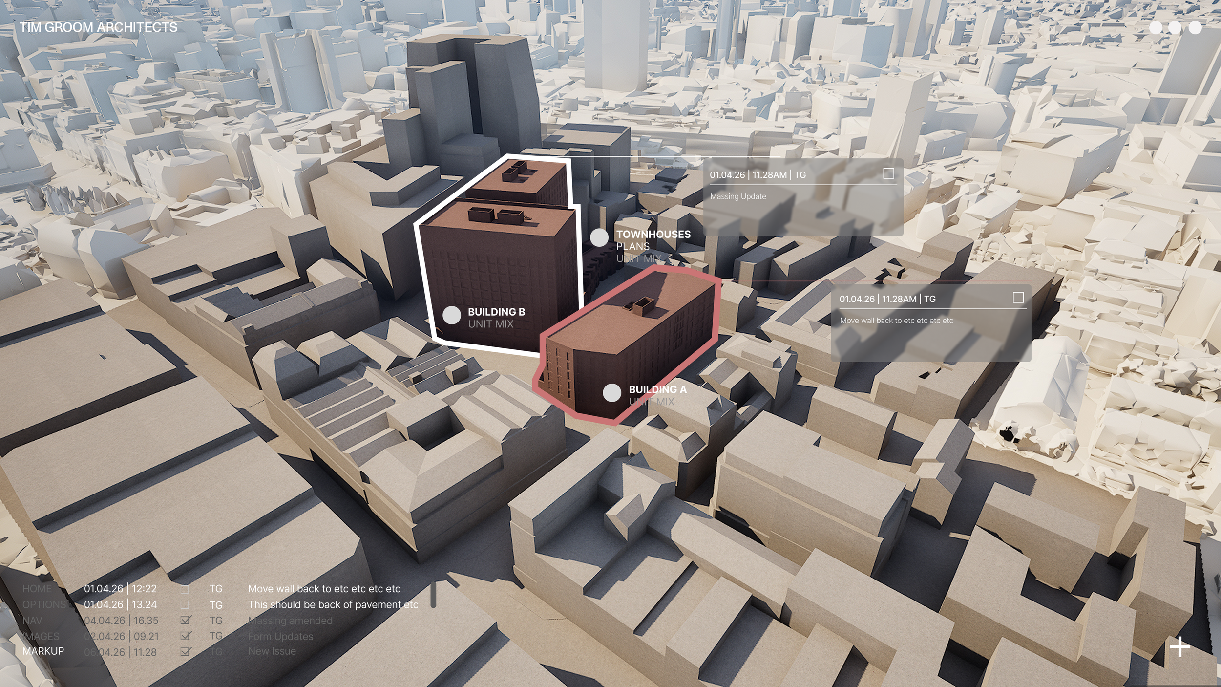
Design Review
Markup & Issue Tracking
Option Comparison
Model Comparison
Clash & Coordination Review
Saved Views & Presentation Sets
-
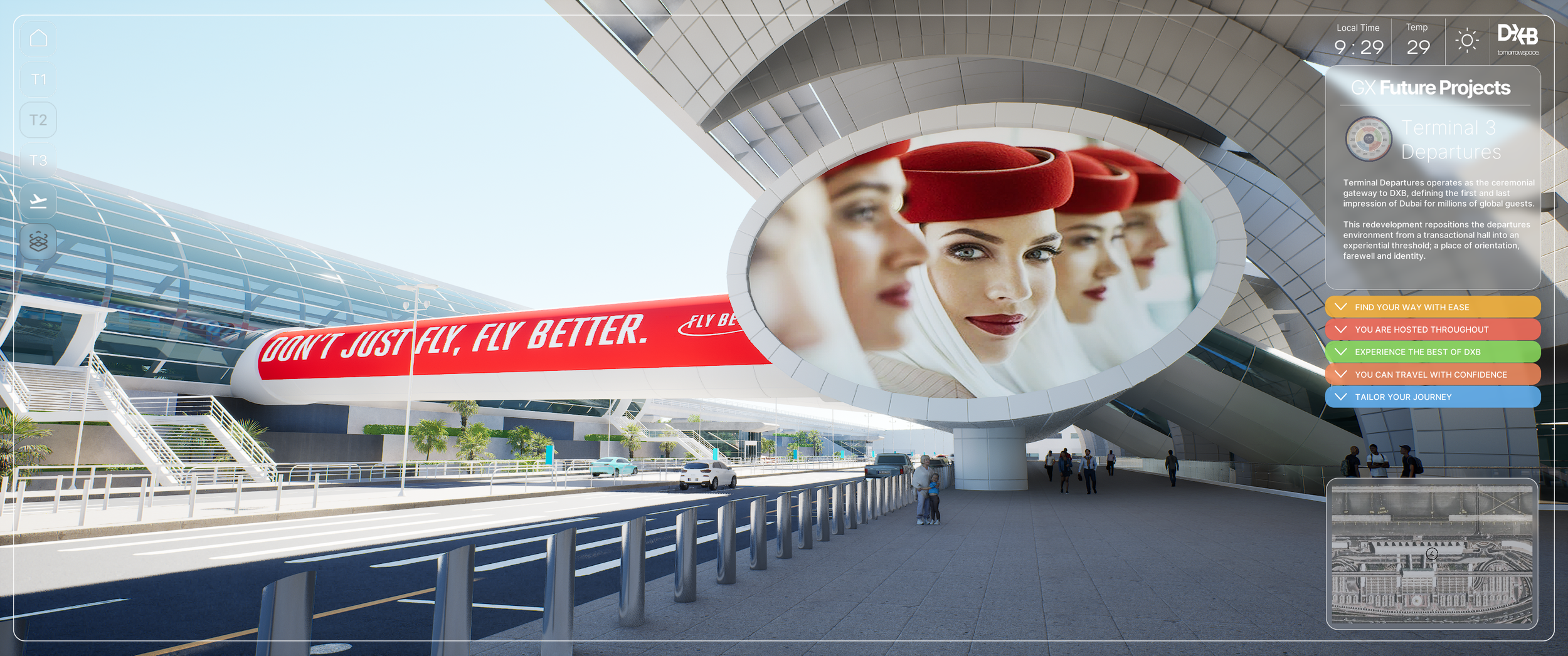
Operational Monitoring
Scenario Testing
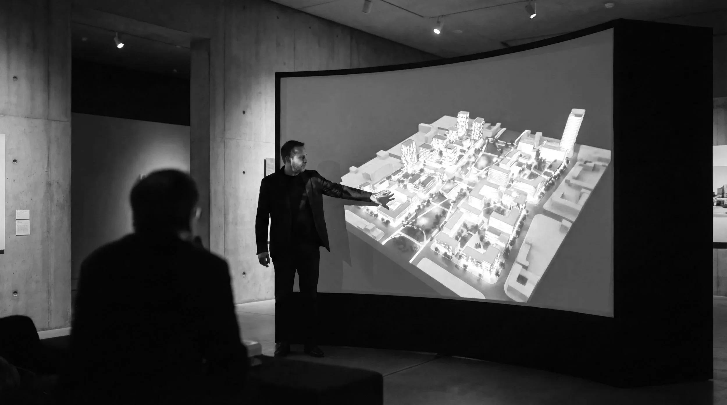
Stakeholder Engagement
Executive Presentation
Multi-user Collaboration
AI Assisted Workflows (future)
-
Asset Information
Data Overlays
Document Linking
GIS & Mapping
Live Data Integration
Dashboards & KPIs
Built for Complexity.
Sectors
Designed for large-scale assets and long-duration programmes where multiple teams, systems and project phases must remain aligned over time.
Typologies include:
airports and aviation infrastructure
rail and transit networks
ports and logistics hubs
urban regeneration and masterplanning
stadiums and major venues
mixed-use and large-scale developments
These are environments where fragmented information slows decisions, increases risk and creates costly disconnects between teams. Tomorrowspace creates the governed spatial layer that keeps the project connected.
Keeping projects, teams and stakeholders connected.
Outcomes
Turning fragmented project information and data into usable spatial understanding.

Coordinate complex programmes
- Review packages, phasing, disciplines and stakeholder inputs inside one shared spatial environment.
Align stakeholders faster
- Give executives, operators, consultants, authorities and delivery teams a single visual reference for discussion and decision-making.
Communicate complex projects clearly
- Turn technical information into navigable, high-fidelity environments that non-technical stakeholders can understand.
Reduce risk caused by fragmented information
- Ensure teams are working from governed, current project data rather than disconnected versions spread across systems.
Build a long-term spatial foundation
- Create a reusable spatial layer that can evolve into future operational, analytical and AI-driven applications over time.
Specialists in persistent spatial environments

About
Tomorrowspace is a specialist digital twin practice creating persistent spatial environments for complex infrastructure, transport and major development projects. The practice combines spatial thinking, visual communication and systems awareness to create project environments that federate and power decision making.
Tomorrowspace twins run on real-time rendering infrastructure, delivering interactive, high-fidelity spatial experiences at scale. The environment is built to be open — as AI-driven analytics, predictive simulation and operational monitoring mature, they connect into the existing foundation rather than requiring it to be rebuilt.
Contact Us
Have a project in mind?
If you’re working on a complex asset, development or network and need a clearer way to connect models, data and people - get in touch.
info@tomorrowspace.com
For vacancies and any other enquiries, please send an email to info@tomorrowspace.com
UK Registered Office
128, City Road,
London,
England
EC1V 2NX
UAE Registered Office
Floor 38, 110.
API Trio Tower
Dubai
UAE